
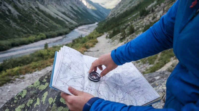
- Why Knowing How to Read a Trail Map Is Essential
- Understanding Trail Map Symbols
- Essential Navigation Tools for Camping
- Step-by-Step Guide to Reading a Trail Map
- Common Mistakes to Avoid While Navigating
- How to Prepare for Trail Navigation Before You Head Out
Why Knowing How to Read a Trail Map Is Essential
Whether you're embarking on a short hike or a multi-day camping trip, knowing how to read a trail map is an essential skill for navigating the great outdoors. Trail maps provide detailed information about terrain, trail routes, landmarks, and elevation changes, helping you plan your route and avoid getting lost. Understanding how to use these maps can be the difference between a successful, enjoyable camping trip and a potentially dangerous situation.

Blue Mountain View Estates
KunkletownCarbon CountyPennsylvania
1 Blue Mountain View, Kunkletown, PA 18058, USA
Understanding Trail Map Symbols
Trail maps use a variety of symbols and markers to convey important information about the terrain. Familiarizing yourself with these symbols will help you navigate effectively. Here are a few common symbols you'll encounter:

Millwood
MontvilleSoutheastern Connecticut Planning RegionConnecticut
3 Hillcrest Dr, Uncasville, CT 06382, USA
1. Trail Routes
Trail routes are typically shown in bold lines on the map. These lines may vary in color or thickness to indicate the difficulty level of the trail. For example, a dashed line may represent a less maintained or secondary trail, while a solid line could indicate a main or primary trail.
2. Elevation Contours
Contours on a trail map are used to show changes in elevation. These lines, known as contour lines, connect points of equal elevation. The closer together the lines are, the steeper the terrain. Learning how to interpret these lines will help you understand the level of difficulty of a trail.
3. Landmarks and Features
Landmarks such as rivers, lakes, and mountain peaks are often marked with icons or symbols. These can serve as useful reference points when navigating, helping you orient yourself on the map and confirm your location in the real world.
Essential Navigation Tools for Camping
While trail maps are an invaluable resource, it’s also important to have the right tools to navigate effectively. Here are some essential navigation tools for camping:
1. Compass
A compass is a vital tool for determining direction. It helps you orient yourself on the trail map and ensures that you're heading in the right direction. Make sure you know how to use a compass in conjunction with your map for accurate navigation.
2. GPS Device or Smartphone
Modern GPS devices or smartphones with navigation apps can enhance your trail map reading skills. However, it’s important to remember that GPS devices can sometimes lose signal in remote areas, so always carry a physical map as a backup.
3. Altimeter
An altimeter measures changes in elevation. This tool can be especially helpful on mountainous trails, as it allows you to gauge your altitude and ensure you're on track by comparing it to the elevation information on your map.
Step-by-Step Guide to Reading a Trail Map
Reading a trail map may seem daunting at first, but with a few basic steps, you can easily get the hang of it. Here’s a simple guide to help you:
1. Orient the Map
Before you begin, orient the map so that it matches the direction you are facing. Use your compass to align the map with the terrain. This will make it easier to match landmarks on the map with the environment around you.
2. Identify Your Starting Point
Next, locate your current position on the map. If you're just starting your hike, find the trailhead or parking lot where you began. If you're already on the trail, look for nearby landmarks such as rivers, peaks, or intersections with other trails.
3. Plan Your Route
Using the map, identify your destination and any waypoints or landmarks along the way. Consider the trail's difficulty, elevation changes, and the distance between stops. Mark these points on your map so you can track your progress as you hike.
4. Keep Track of Your Location
As you walk, periodically check your surroundings against the map. Pay attention to the terrain and landmarks that match what you see around you. This will help you stay on course and avoid taking a wrong turn.
Common Mistakes to Avoid While Navigating
Even experienced hikers can make mistakes when navigating. Here are some common mistakes to avoid:
1. Not Updating Your Location Regularly
Failing to update your position on the map as you move along the trail is a common mistake. Regularly checking your progress ensures that you're staying on the right path and helps you make adjustments if necessary.
2. Ignoring Elevation Changes
Elevation is a critical factor in trail navigation. Ignoring it can lead to confusion, especially on trails with steep ascents or descents. Always be aware of how the terrain changes as you hike and compare it to the map’s contour lines.
3. Relying Solely on Technology
While GPS devices and smartphones are helpful, they’re not foolproof. Batteries can die, and signals can be lost. Always carry a physical map and compass as a backup to ensure you're prepared in case of technology failure.
How to Prepare for Trail Navigation Before You Head Out
Preparation is key when it comes to navigating trails safely. Here’s how to get ready:
1. Study the Map Beforehand
Take some time before your hike to study the trail map. Familiarize yourself with the route, landmarks, and potential hazards. Knowing what to expect ahead of time will help you feel more confident on the trail.
2. Pack the Right Tools
Make sure to pack a compass, GPS device (if available), and any other navigation tools you may need. Don’t forget to carry extra batteries or a power bank for your devices.
3. Know the Weather
Check the weather forecast before you head out. Severe weather can affect visibility and trail conditions, so it’s important to be prepared for any changes in the environment.
Ready to start your next camping adventure? Explore more tools, maps, and camping gear at Camping Cabins to ensure you’re fully equipped for your next outdoor journey!


 Pines at West Penn LLC4.0 (8 reviews)
 BigMount Glamping5.0 (4 reviews)
 Avalon Campground4.0 (330 reviews)
 Pine Acres Manor Mobile Home Sales4.0 (27 reviews)
 Bayshore Campgrounds4.0 (289 reviews)
 Breezy Point Beach & Campground4.0 (1244 reviews)
 Why Winter is the Best Time for a Camping Cabin Getaway
 Best Remote Camping Cabins for Stargazing and Night Adventures in the U.S.
 The 10 Must-Have Amenities for a Comfortable Stay in Your Camping Cabin
 Winter Camping Cabins: How to Stay Cozy and Warm in the Cold
 How to Create the Ultimate Outdoor Experience with a Camping Cabin
 Best Camping Cabins with Stunning Views of National Parks and Forests